
Shvil Israel - the Israeli trail
The Israel National Trail (Shvil Israel) is a 1,000 km journey from Dan in the north to Eilat in the south.
The trail is divided into 53 segments. Hikers can choose to walk a specific section of the trail, however, many young adventurers embark on the full journey, completing all segments consecutively.
Year
2025
Role
Product, UX, UI
Tools
Figma
Team
Personal Project
The Problem
Current Situation
There is no official website for the Israel National Trail. Information is scattered across various hiking and nature reserve websites, and there is no single, reliable, and unified source of information about the trail.
The existing mobile app is very basic, with missing features and aspects that make it less user-friendly.
The Need
Official Website + App
Standardization and Centralization of Information - Establishing an official website for the Israel National Trail that consolidates all essential information for hikers. This includes creating a unified language regarding the trail, with a clear division of segments, real-time updates from the field, and ratings of trail segments based on difficulty level, interest level, and other relevant factors.
The Client
Society Protection of Nature in Israel
Core values include nature conservation, environmental awareness, and education to promote knowledge and appreciation of the land.
Users
App vs. Web Users
The largest age group among hikers on the Israel National Trail is 18-25, making up approximately 30% of all hikers. For a single-day hike, most people wouldn’t download an app, therefore, the app is designed for those planning to hike the entire trail.
Persona 1
-
Completing the Entire Trail
-
Chooses a direction: South to North / North to South
-
May want to plan ahead and decide on the best starting point
-
Needs guidance along the way (via an app)
-
Requires a navigation map
-
Seeks information about different trail sections and points of interest
-
Needs details on water sources, campsites, and Trail Angels
Persona 2
-
Hiking a Specific Segment of the Trail
-
Interested in exploring available trail segments
-
Likely wants to choose a specific region or find a trail near their location
-
Looks for suitable difficulty levels, family-friendly routes, or nearby attractions
-
Unlikely to download an app just for a single-day hike
Wireframes
Mapping the App

Missing Features Added
Dashboard + Profile
1. Dashboard - Information relevant to the upcoming hiking day. Allowing users to track their progress while keeping the focus on one day at a time - rather than overwhelming them with the entire map and all trail segments at once.
2. Profile - Here users can not only access their information and settings, but also save and keep track of the trails they completed, comments they wrote, etc.

Onboarding
Creating a better experience
The app is designed for users who are hiking the entire Israel National Trail. The trail sections are displayed in order from north to south or from south to north, depending on the starting point the user selects. Research showed that some hikers wanted help or advice regarding the preparation phase, specifically about the necessary or recommended gear. Here while they onboard the app they can get access to a list with that information.

Trails view
Allowing better access to information
The existing app has no dedicated place where users can view all trail segments and sort or filter them based on specific criteria. A full page for each segment is able to contain more information in a clearer and less overloaded way.

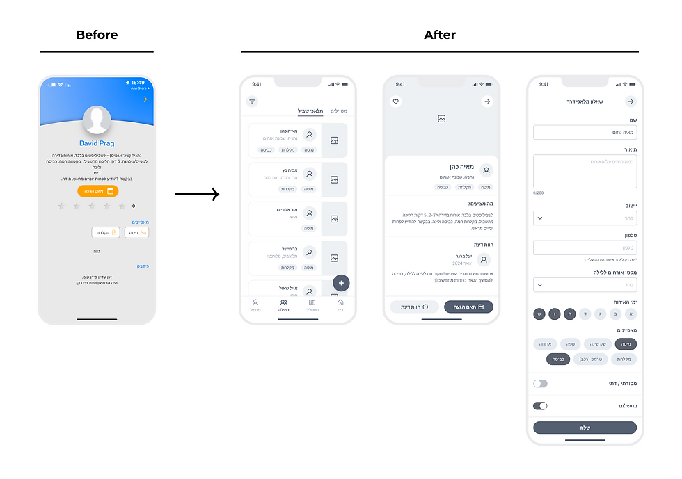
Community
Making Help & Hospitality Available
A place where users can look for 'Trail Angels' - volunteers who offer assistance and hospitality to hikers.
Users can view a list of them and filter by location (nearby or along a specific trail segment) or by services offered (e.g., accommodation, water refill, showers, meals, transportation assistance etc.)
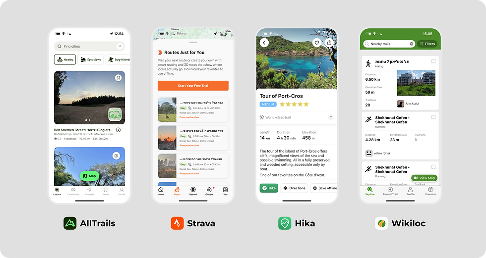
Market Research
Hiking & Trails apps
Researching some of the more popular apps allowed me to understand which information is most valuable to the users while on the trail. Unlike the existing 'Shvil Israel' app, here the ability to monitor the progress and have visibility over it was in very high priority .
Design
Simple & Noticeable
The color palette comes from the "Shvil Israel" trail sign colors. Earthy and natural, fitting well with a hiking related app. The orange appears clearly on the map as the trail and blue is for the buttons, catches the eye and easy to find.

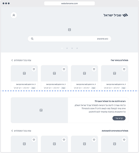
The Website
Easy to Find, Share & Keep Track
Users coming to the website want to see the selection of trails. They can see what trail is near them and easy to access or filter / sort by a certain parameter (difficulty level, family-friendly, things to do in the area, etc.). The user can save trails for later or share to family or friends to set a trip together.

.png)